How has the City of Courtenay’s growth changed the river?
The City of Courtenay is shoring up the banks of the Courtenay River to protect infrastructure from future flood events.
This is part two of a story on the Anderton Arms apartments. The previous article looks into the City of Courtenay’s decision to demolish the apartment building. There will be a third story on the City of Courtenay’s Flood Mapping Project to come. Sign up for our newsletter to be the first to read it.
Residents of the City of Courtenay are no strangers to flooding, and with much of the city’s downtown core being near or within the Courtenay River’s floodplain, that comes as no surprise.
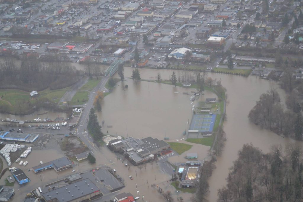
In 2009, a state of emergency was declared after heavy rains flooded low-lying areas of the City of Courtenay. Another state of emergency was declared in the Comox Valley in the winter of 2014 to 2015. A total of 200 millimetres of rain fell in a 36-hour period and resulted in multiple road closures and the closure of the 5th Street and Dove Creek bridges.
During the 2009 flood, the city evacuated 54 people from Maple Pool Campsite and RV Park, which is about 1.5 kilometres from the Anderton Arms apartment complex. The Anderton Arms building is on the bank of the Courtenay River and is set to be demolished for a number of reasons, including changes to the river’s flow that has impacted the land underneath the apartments.

The building was not up to seismic code, and various structural assessments revealed that the land and building was unstable. The retaining wall in place along the river and the building was also unstable, partly due to the river’s behaviour as it eroded soil behind the wall, and needed upgrades that would require extensive work.
But the two main reasons that led to the city’s decision to demolish Anderton Arms came down to erosion and flooding, according to the City of Courtenay’s manager of environmental engineering Jeanniene Tazzioli. Before the retaining wall was put in place, a log wall was constructed along the Courtenay river as a way to straighten it out and train it. But Tazzioli says structures like that can only last so long when the river’s forces are so strong.
“If we just repair the [retaining] wall, we would find ourselves in the same situation perhaps in 10 years, perhaps in 20 years … We know that straightening rivers increases flood risk because they are not able to dissipate their energy as they would if they were left in a natural meandering state,” Tazzioli said.
The flooding and erosion issues faced by the city today are a result of development, industry and an attempt to control the river, in combination with weather events that become more extreme as the climate changes.
Now, the City must find ways to ensure floodwater from the river doesn’t disrupt critical infrastructure in the community or compromise people’s homes, the way Anderton Arms was compromised.
“We really want to make sure we are taking effective action so we don’t just keep perpetuating the risk and perpetuating the problems,” Tazzioli said.
What is the industrial history of the Courtenay River?
Over the years, the Courtenay River has been impacted by industrial developments that came about post-colonization.
The river and its surrounding lands have been stewarded for thousands of years by ancestors of the K’ómoks First Nation — descendants of the Sathloot, Sasitla, Ieeksen, Xa’xe and Pentlatch. Many surrounding areas get their namesake from the Éy7á7juuthem, Kwak̓wala, and Pəntl’áč languages — including the Puntledge River and the Tsolum River.
Prior to the arrival of settlers and colonization, the Courtenay River had options to meander into its many tributaries and its floodplains as water levels changed through the seasons, but it has since been choked by various man-made industrial walls or structures.
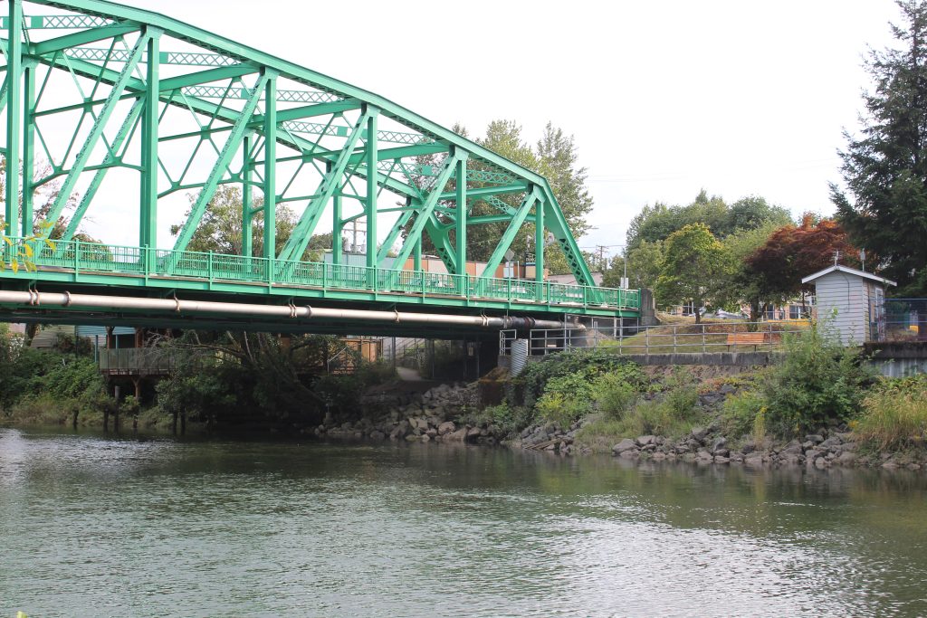
Dusty Silvester, a registered professional biologist with Current Environmental, told the Discourse that the Courtenay River Corridor — the area downstream from where the Puntledge and Tsolum rivers converge — has been heavily modified over time since the late 1800s when the 5th Street bridge was built.
At the time, early settlers in Courtenay prioritized the removal of vegetation from the area, and manipulated the river banks to support commercial and industrial businesses along the waterfront.
“Water access from the Courtenay River was instrumental to some of these businesses, including the Pidcock Mill on the west side of the river that would ship lumber on barges down the river,” Silvester said.
What did the riparian area along the Courtenay River look like historically?
Riparian ecosystems are made up of the transitional areas between water and land. They have characteristics of both aquatic and terrestrial ecosystems, such as fallen trees that are both on the land and in the water or fish carcasses that have been deposited on land. They also include animals that are both on the land and in the water, such as beavers or otters.
In a previous story for The Discourse, Shalu Mehta wrote about how riparian ecosystems are crucial for the benefit of both water quality and plant and animal habitat.
Silvester said the most intact riparian vegetation that resembles what would have been historically present along the Courtenay River can be seen downstream of where the Tsolum and Puntledge Rivers Merge, west of the Old Island Hwy and Headquarters Road (near the Puntledge RV campground).
The vegetation along the banks of the Courtenay River today is still recovering from these historical changes, Silvester explained. After an ecosystem is disrupted, it moves through what is called ecological succession, which is how a habitat changes over time to become stable again after being disrupted.
This area, he explained, forms part of the Courtenay River floodplain. The vegetation is capable of withstanding heavy rainfall and high amounts of water in the wet season, and is what was likely present historically in the area that is now referred to as the City of Courtenay. In the downtown area of Courtenay, Simms Millennium Park is also an example of a relatively intact riparian area, although evidence of wooden piles along the east bank of the river show that parts of it were cleared to support industrial and commercial activity.
“All of the riparian vegetation observed today along the Courtenay River is recovering from past clearing and land-use modifications,” he added.
Where are the floodplains in Courtenay?
“The entire area between the Courtenay River in the west and roughly Back Road in the east is floodplain where the Courtenay River would have historically been allowed to meander back and forth over millennia,” Silvester said.
Much of this area has been converted for agriculture, but there are commercial and residential areas along the Ryan Road corridor.
“Periodically [the river] will spill [over] its banks and spread into its floodplain — mostly visible in Lewis Park. This flooding has long been recognized (I recall a local urban myth of someone paddling a canoe into the first floor of the Courtenay Hotel) with a common reminder present in the winter when the City deploys an Aqua Dam along the Lewis Park bike path,” Silvester said.
An Aqua Dam is a patented portable flood barrier composed of two water-tight tubes that fill during flooding, creating a barrier that helps control and divert water.
How is the city containing the river right now?
Silvester explained that the Courtenay River is contained mostly by “hard armouring,” which refers to the use of physical structures such as riprap (large diameter rock), concrete retaining walls and/or metal sheet piles to protect shorelines from erosion.
But another technique — “soft armourning” or “greenshores” — may be the solution for the future of managing waterways. This technique mimics nature’s own design and promotes healthy riparian areas by restoring the vegetation in them, Silvester said. This is the technique the city of Courtenay will be using to restore the area that Anderton Arms currently sits on.
“In practice, hard armouring is still used, and remains suitable in cases where critical infrastructure may be at risk (for example, major bridge abutments) and/or where erosive forces from river flows, ocean currents and winds causing wave run-up or storm surges are prevalent,” Silvester said.
What’s the best option for Anderton Arms?
Silvester confirmed that the location of the Anderton Arms apartments are well within the Courtenay River riparian area.
“Typically, when a structure is demolished within a riparian area either a new structure can be established within the same footprint or the area is to be naturalized,” he said.
“If engineering has dictated that the existing footprint is untenable for re-development, the obvious alternative, at least worthy of discussion, is to restore the area by assessing whether the banks can be regraded … and restored with native vegetation to return some of the natural function of the riparian area.”
He added that this wouldn’t come without challenges, considering the nearby armouring that is already in place both up and downstream in the form of a retaining wall.
According to Tazzioli, the City of Courtenay is looking to re-establish the riparian area where Anderton Arms is along the Courtenay River after the building is demolished.
“We are planning follow up phases for preliminary and detailed design, and with that, we want to find ways of blending engineering with biology,” she said, but added that the project is still very much in the planning stage.
What is the City of Courtenay’s plan for flood management?

Tazzioli told The Discourse that the City of Courtenay is hoping to spread the word to residents about its Flood Management Plan. It builds off past work from the city’s Official Community Plan, as well as the Comox Valley Regional District’s Coastal Flood Mapping Project and Coastal Flood Adaptation Strategy.
More information about the City of Courtenay’s historic flood events can be found online, as well as a map of the floodplain in the CVRD.
Stay tuned for a story about the City of Courtenay’s Flood Mapping Project. Sign up for our newsletter to be the first to read it.
What did you think of this story?
Your feedback after we publish a story helps ensure we're always improving our reporting to better serve you
Author

Related Articles
Residents upset with Aspen Road development in Comox
Comox councillor says housing development should be balanced with community compassion
Q&A: Palestinian chef brings traditional cooking and food history to Vancouver Island
Izzeldin Bukhari speaks on the origin of falafel, Gaza’s rummaniyeh and why he sees food as a way to hold on to a culture under threat.
Pulse on the Plaza jumpstarts the heartbeat of Courtenay’s downtown
Fusion of cultures the ‘secret sauce’ of the festival series’ success, Comox Valley Arts director says.