
What is Nanaimo’s new Sea Level Rise Management Plan?
After nearly a decade of work, Nanaimo’s plan to manage sea level rise aims to help the city adapt as the climate changes.
As we start to see more impacts of climate change both globally and locally, seaside communities are looking for ways to plan for sea level rise and mitigate the potential damage it may cause.
For nearly a decade, the City of Nanaimo has been working on a Sea Level Rise Management Plan and in September the city announced that the plan, titled Our Coastal City, is complete.
The new plan helps the city understand its coastal risks and also offers management options, focusing on areas of the city that are most vulnerable to sea level rise. It was completed in two phases in coordination with the Regional District of Nanaimo’s four-year Our Changing Coast project, which has an end goal of creating a Coastal Climate Adaptation Strategy for the region.
“As our climate warms, sea levels are rising for a couple reasons,” said David Stewart, environmental planner with the City of Nanaimo.
“One, actually, the ocean water is expanding slightly as it gets warmer, and the other one that I think more people are familiar with is as polar ice caps melt, all that ice gets into the water and raises the water.”
Stewart said sea level rise isn’t constant throughout the world, and who is more impacted will depend on the area.
“In Nanaimo, we expect just under a metre of sea level rise by approximately [the year] 2100,” he said.
What areas of Nanaimo are most susceptible to sea level rise?
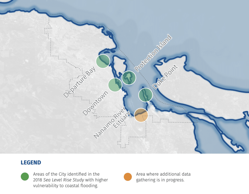
Stewart said the Sea Level Rise Management Plan builds on a 2018 study that identified which areas in Nanaimo are most vulnerable to sea level rise and storm surge for the years 2050 and 2100.
The study identified four low-lying areas in the city that are considered high risk when it comes to sea level rise. Those four areas are Departure Bay, Duke Point, Protection Island and areas of downtown Nanaimo.
“While present-day coastal flood risk is generally relatively low, with the exception of Departure Bay and Protection Island during larger storms, damages increase across all areas at 0.5 metres RSLR [relative sea level rise], rise substantially at one metre and increase sharply at two metres,” a report presented at a Sept. 28 governance and priorities committee meeting reads.
Relative sea level rise refers to the height of the ocean as compared to the land beside it.
Areas in Nanaimo will be impacted differently depending on location, Stewart said.
Even smaller areas can be impacted differently.
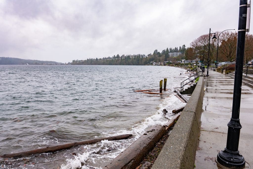
For example, if an area — such as Departure Bay — has a sandy beach, a sea wall and a mixed-use village, the risks associated with sea level rise will be much different than areas such as the Cilaire neighbourhood which has steep cliffs where flooding is less of an issue compared to erosion.
“That’s one of the big challenges with this work, and one of the more interesting things is every little section is different and requires a different analysis and a different approach,” Stewart said.
What is the sea level rise management plan?
According to the Sep. 28 report, the Sea Level Rise Management Plan involved calculating future sea level rise and inundation (the rising and spreading of water), modeling of what this would look like, an economic risk assessment, management options for the city, a coastal erosion monitoring plan and a communication strategy.
The report said all of the tasks associated with the project are complete, with the exception of the ongoing communication strategy work.
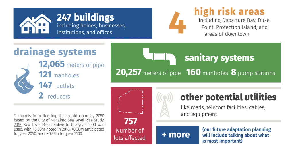
As part of the plan, floodplain maps and models were created and used to identify areas that are expected to flood under future climate conditions on average once every 200 years. These floodplain models inform future development in the areas most at risk in Nanaimo and help assess the risk of future flooding to buildings, roads and critical infrastructure in those areas.
The plan also developed some recommendations for the city to adapt in the four high-risk areas in response to sea level rise. These include updating and relocating future infrastructure, discouraging new developments within certain high-risk sea level rise areas wherever possible and a continuation of community engagement.
The report says that in some cases, collaboration will also be required across municipal boundaries with Snuneymuxw First Nation, the province, the regional district and other interest holders such as BC Ferries and the Nanaimo Port Authority.
The full recommendations can be found on pages two and three of the Sept. 28 report.
Why is this plan needed?
As part of the Sea Level Rise Management Plan, Stewart said the city not only looked at rising ocean levels, but also the impacts from storm surges, king tides and flooding. The combinations of these events can impact and aggravate the effects of sea level rise.
King tides are exceptionally high tides that occur at certain times of the year due to gravitational forces. They happen twice a year and are often stronger during winter.
“The mapping we’ve done simulates wave levels and expected wave levels as well as looking at average tides and trying to look at the probability of those events occurring around the same time.” Stewart said.
Kees Lokman, an associate professor of landscape architecture at the University of British Columbia, told The Discourse that these plans are important in order to manage what he calls “cascading impacts” of sea level rise.
“A good example would be if you have a water treatment plant that might be in the floodplain, or along the coast or [otherwise] impacted by sea level rise, if that particular water treatment plant is impacted, that might cause a backup of sewage,” Lokman said.
These effects are cascading because it begins with one place or system being impacted, but then cascades out, according to Lokman. The electricity grid is also at risk, as well as supply chains and transportation routes.
“You might have a highway that’s a major road to a hospital that’s been flooded so that some communities or buses cannot get to the hospital anymore,” Lokman said.
How can residents learn more about sea level rise in their area?
The public engagement survey for Nanaimo’s Sea Level Rise Management Plan is now closed, but residents can check out the city’s Get Involved Nanaimo page and click on the adaptation toolkit to learn more specifics about the project.
The Sea Level Rise Management Plan page on the city’s website, and the Our Coastal City document also has more information, although the city is still working on its communications around this plan.
Stewart also welcomed community members to contact the city’s sustainability department through the emails on the city’s website if they want to learn more about how sea level rise impacts their homes or neighbourhoods.
“I think the key message for the public, especially coastal property owners, is yes, this is something that we need to be concerned about. But in terms of impacts, it’s not something that’s happening overnight. We have time. We can work together on this, ” Stewart said.
Lokman said for people who want to learn more about how their homes and areas will be impacted, looking at recent flood maps and learning whether their house is within a zone that may face flooding is a good place to start.
But he thinks it’s important that these plans go beyond an individual level.
“Try to understand where you’re situated, but [also] have an open mind about thinking of the future not so much in your lifetime but in the lifetime of kids and grandkids,” he said.
He said he thinks it’s important to allow the spaces near water to be dynamic, and organize our cities in a way that reducing risk doesn’t rely on building separation between water and ourselves.
“I think that’s why we’re often living in deltas and along rivers because I think those spaces are incredibly rich for biodiversity but also experientially.”
What did you think of this story?
Your feedback after we publish a story helps ensure we're always improving our reporting to better serve you
Related Articles
From a campus gallery to a community hub, Nanaimo Art Gallery is outgrowing its home
For five decades, the Nanaimo Art Gallery has created spaces for community, curiosity and reflection through art.
DRIPA debated in B.C. election on Vancouver Island
The Conservative party of B.C. is promising to repeal the Declaration on the Rights of Indigenous Peoples Act (DRIPA), while other parties argue that would set back relations with First Nations and create economic uncertainty.
Where Nanaimo’s MLA candidates stand on addictions care, family doctors and Island rail
Candidates in Nanaimo-Gabriola and Nanaimo-Lantzville answered three questions from Discourse readers ahead of the Oct. 24 B.C. election.