Some community members are raising concerns about a major restoration project planned for the Cowichan estuary, including plans to convert farmland back to marsh habitat in an effort to restore important and endangered ecosystems.
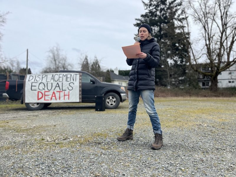
Last week, community members gathered for a town hall to discuss concerns and ask questions about the Cowichan Estuary Restoration Project. A citizen group called the Land Keepers Leadership Society organized the meeting, which attracted a full house of community members, including local farmers and politicians.
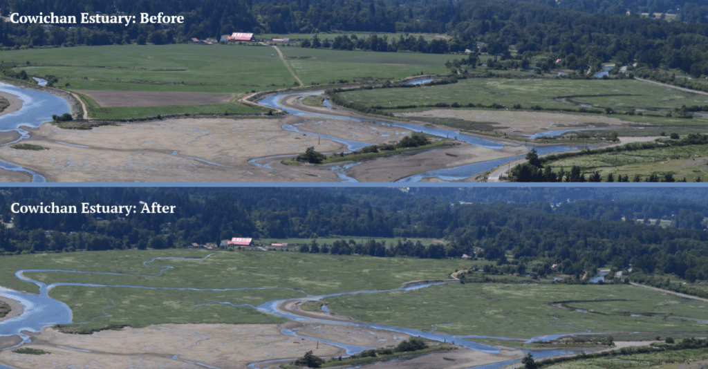
Many attendees raised concerns about the restoration project’s impacts on local agriculture and food security. The project, which was announced this past spring, will involve removing a dike that is currently keeping ocean water from flooding the historic Dinsdale Farm property. The Nature Trust of B.C. and Ducks Unlimited Canada purchased the land from the Dinsdale family in 1990 as part of a campaign to protect and restore the estuary, and have since maintained the farmland through lease agreements with farmers.
Now, the land owners and their project partners plan to remove the dikes around the property, and encourage the land to transform back into the estuary marsh it used to be. Similar activity in the adjacent Koksilah Marsh aims to improve habitat there, too. In all, the Cowichan Estuary Restoration Project aims to restore 70 hectares of marshland. It is proposed to become the largest estuary restoration project to ever take place on Vancouver Island.
The project’s goal is to improve estuary habitat, for now and for the future. Rising sea levels, caused by climate change, threaten to further squeeze out this important ecosystem. Estuaries make up just 2.3 per cent of B.C.’s coastline, and 80 percent of coastal species rely on them at some point in their life cycle.
Read more: Cowichan estuary restoration will combat impacts of sea-level rise
The restoration work would give the marshland room to move inland as waters rise, and would provide natural protection against flooding elsewhere. But these benefits would come at a cost, with the loss of a productive farm and the popular walking trail along the dike that borders it.
Community members at the town hall meeting sought to understand more about the project and its risks and benefits. However, many questions went unanswered, and inaccurate information about the project was shared as well. Jack McLeod, a director of the Land Keepers Leadership Society, declined an interview request.
Project representatives from the Nature Trust of B.C. weren’t invited to the meeting to directly respond to community questions and concerns. In light of this, The Discourse reached out to the Nature Trust of B.C. in an effort to answer questions that surfaced at the town hall and were sent to us via email.
What’s the history of this land?
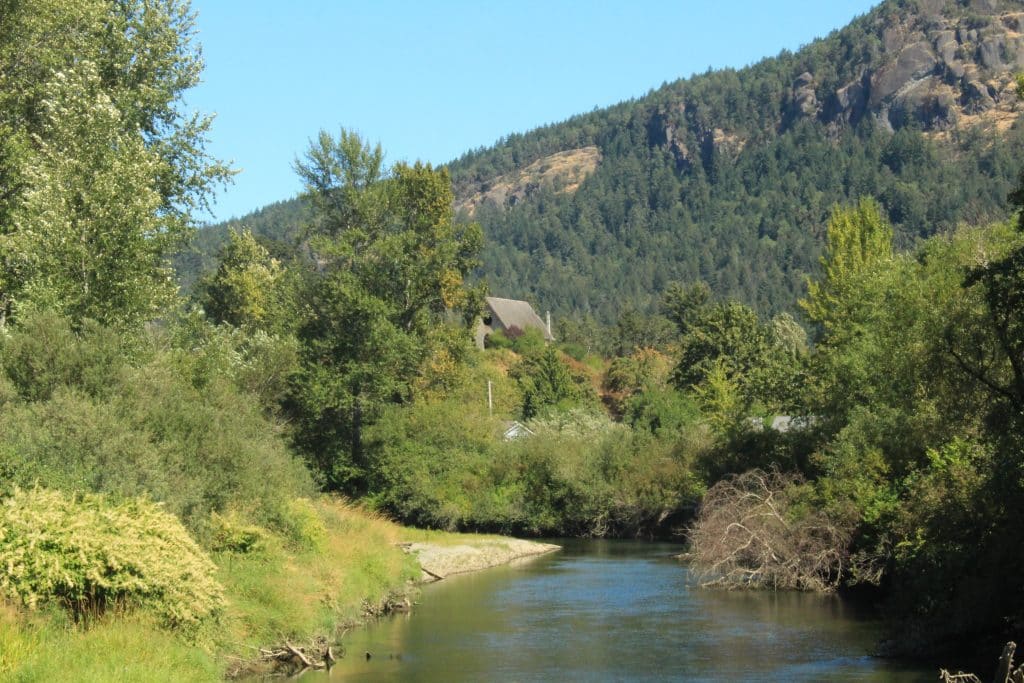
The Cowichan estuary is where the Xwulqw’selu Sta’lo’ (Koksilah River) and Quw’utsun Sta’lo’ (Cowichan River) meet the ocean. Both rivers weave through the unceded homelands of the Quw’utsun People (Cowichan People).
Coast Salish food sovereignty advocate and cultural educator Jared Qwustenuxun Williams previously reported for The Discourse about the significance of watersheds and wrote about the abundance of food — like shellfish — that could be found in the estuary. He called it a “place of endless bounty” that has now grown sparse.
Smaalthun (Larry George), Cowichan Tribes’ director of Lulumexun Lands and Self-Governance said in a statement that was sent to The Discourse in June that “the Quw’utsun Mustimuhw have long been stewards of the lands and waters” that make up the Cowichan estuary. But Quw’utsun People have watched the estuary change over the decades since the land was taken by settlers.
Read more: How colonization dismantled Coast Salish food systems
Jason Emery, director of conservation and land management with the Nature Trust of B.C. says the area around the Cowichan estuary has been farmed since settlers arrived in the region in the 1800s. In the mid-1980s, the Nature Trust of B.C. began engaging with the Dinsdale Farm landowners — the Dinsdale family — as part of a larger effort to conserve and restore estuary lands.
A 1984 document from the Department of Fisheries and Oceans makes note of negotiations to buy the land that took place at the time, and the intent to return the land “to the effects of tidal and river waters.” Removing the dike would increase habitat for fish and wildlife, the document says.
Anne Dinsdale, matriarch of the Dinsdale family at the time, was quoted as supportive of returning the farmland to natural processes, Emery says.
But that restoration work did not immediately take place. It was mutually beneficial, at the time, to lease the land back to farmers, he says. Ducks Unlimited Canada and the Nature Trust of B.C. generated a modest amount of revenue from the lease and remnant crops provided food for migratory birds like Canada Geese and other waterfowl.
Why is this happening now?
A few years ago, in response to concerns around climate change and sea-level rise, the Nature Trust embarked on a study examining the resilience of 15 different estuaries in B.C, Emery says. They collected data from the estuaries on sediment, marsh habitat, water levels and more. The data revealed that estuary environments — including that of the Cowichan estuary — are facing a real threat from sea-level rise.
“We’ll lose a lot of the coastal marsh that currently sits out in front of the current dike. There’s nowhere for it to move, essentially,” Emery says. “And so, over time, it loses its ability to sustain itself and then becomes permanently inundated with water.”
The Cowichan Estuary Restoration Project eventually came about in response to this data, as a way to restore estuary processes and improve estuary functionality.
“In this case, this becomes a trade off,” Emery says. “Farming was certainly supported and we ran with that for many years. Now, with what we see out there, we have an opportunity to make a change that caters to … outdoor spaces, wildlife ecosystems and conservation in general.”
The project came out of years of consultation, research and monitoring, according to a statement from B.C.’s Ministry of Water, Land and Resource Stewardship. Learnings from the work highlighted a need for this project to take place to ensure the Cowichan estuary is resilient and healthy in the long-term.
Estuary restoration projects in the province support many coastal species, “including wild Pacific salmon, steelhead, shorebirds, waterfowl, short-eared owls, grizzly bears and orcas, as well as many commercially and recreationally important fish stocks, including herring, crabs, clams, oysters, and other forage fish species,” the statement says.

The $3 million project costs will come from the British Columbia Salmon Restoration and Innovation Fund, with contributions from the provincial and federal governments and Cowichan Tribes.
The farmer currently leasing the land received communication from the Nature Trust early on, Emery says, when monitoring and measurement work in the estuary began. The province’s statement says project timelines were adjusted to allow the farmer an additional farming season to transition off the farm. The farmer voluntarily ended the lease and was compensated through mutual agreement.
“We were very transparent about what we were working on; what we were planning to potentially do,” Emery says. “It’s maybe a bit unfortunate, those conversations didn’t reveal that there was maybe some discontent from the farmer about moving in this direction. And then after signing the paperwork and receiving compensation, we started to hear a little bit more about potentially a bit of blowback.”
Who has been consulted?
At the town hall, community members who live near the estuary said the first time they heard about the project was in the spring when local news outlets reported on it. They shared many questions about the project and frustration over the lack of public consultation — especially when the provincial and federal governments are spending taxpayer money on the project.
McLeod, with the Land Keepers, told meeting attendees that the project planning was “done behind closed doors” with “no public consultation whatsoever.”
However, Emery says the Nature Trust has met its obligations to consult on the project, including with neighbouring properties that may be affected by the dike removal.
Project partners also had discussions with Cowichan Tribes Chief and Council, local government, the Cowichan Flood Management Working Group and the Cowichan Watershed Board, Emery says.
The Quw’utsun People, who hold inextinguishable rights on these lands, are partners in the Cowichan Estuary Restoration Project. The Discourse reached out to Cowichan Tribes but did not receive a response by publication time, as its offices regularly close for the month of August.
Additional project partners include the Ministry of Water, Land and Resource Stewardship; the Ministry of Forests; Fisheries and Oceans Canada, Environment and Climate Change Canada and the Habitat Conservation Trust Foundation.
At the town hall, CVRD director Hilary Abbott, who represents the Cowichan Bay area, said he would bring resident concerns to the CVRD board and suggest a “more fulsome discussion” about the project with the community.
However, the CVRD is unlikely to have a say on how or if the project proceeds. The land falls within the Agricultural Land Reserve (ALR), and conservation activities are a permitted use. A rezoning process through the CVRD, including public consultation, is not required.
The Land Keepers’ website says the group aims to empower landowners and uphold “the owner’s right to operate profitably.” However, the land in question is owned by the conservation groups, not the farmer. The Nature Trust and Ducks Unlimited hold the decision-making power for how the land is used, and the project does not infringe on their rights as private land owners.
The Nature Trust of B.C. says a future information session about the restoration project is planned, and that more information about this is coming soon.
Will the project hurt local food security?
At the town hall meeting, community members asked how the project is beneficial when farmland is being lost as part of it.
“We want real clarity in our minds what the pros and cons are, the reasons why it would be positive to flood [the farmland],” one community member said. “What is the real reason for it? Does it actually help the fish?”
Ian Paton, MLA for Delta South with the BC United Party and shadow minister for agriculture and food was also in attendance at the town hall meeting. He is a dairy farmer himself and travels across the province to hear from farmers about issues they are facing — including climate-change related issues like drought, fires, flooding and lack of feed. He raised concerns about the loss of farmland, and impacts on food security.
“My dad was chairman of the Agricultural Land Commission in the late-80’s, early-90’s,” Paton said at the meeting. “He would be rolling over in his grave right now if he could see what’s happening out in Cowichan Bay.”
In an interview with The Discourse, Paton says that while he understands there are issues related to climate change, such as sea-level rise and increasing temperatures, he also wants to make sure farmers continue to have good quality farmland to grow food. He questions what would happen to birds that forage on crops in the farmer’s field and where people would go to recreate if the popular dike trail — used for birdwatching, exercise and berry harvesting — is removed.
Read more: Food for Thought: A solutions series on food and farming in the Cowichan Valley
Instead of flooding farmland, Paton suggested other climate change mitigation measures such as water collection and storage solutions to ensure farmers aren’t impacted by summer drought. He points to lands near the former Dinsdale Farm in the estuary that have already been flooded as part of previous conservation projects and questions why more land has to be flooded.
“There’s got to be a compromise. Some of it has already been flooded out as part of the enhancement of the estuary,” Paton says. “It’s a tough call, but I mean, agriculture is very important. Food security is very important. So we can’t just say, every time an environmental group wants to do something with farmland, we can’t just roll over and say that’s OK.”
Emery says that while farmland is being lost as a result of the project, it comprises less than half of one per cent of farmland in the Cowichan Valley. Birds who use that land to nest and feed are likely to find other places to go. He notes that food security is still being supported by the estuary restoration project because the estuary environment supports food derived from the ocean. This includes food that Quw’utsun People have relied on for millennia.
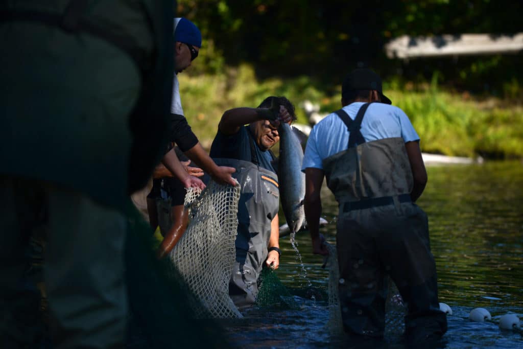
Seventy-five per cent of species that end up being harvested by commercial fisheries depend on estuaries as a key part of their life cycle, Emery says. Juvenile salmon, for example, need estuaries in order to acclimate to saltwater as they leave freshwater rivers for the ocean. Shellfish are also in abundance in estuary environments.
While shellfish harvesting currently doesn’t take place in the estuary due to contaminants in the water, Emery says restoring estuary function will also help clean up the water. Research shows that estuaries are capable of filtering out sediment and pollutants that come from upland areas.
“This project is not a fix to contamination, but when you do have an estuary functioning more correctly, naturally, where you have better flow of water, better in and out movement of tide that’s interacting with water coming out of the river systems, it’s essentially a continual flushing,” Emery says. “There’s a lot of work that will demonstrate that it certainly can dilute contamination in a location by virtue of just being able to have more of that exchange of water back and forth.”
An upswing in shellfish populations — supported by the estuary restoration project — can also benefit water quality because shellfish naturally filter the water, Emery says.
While responding to concerns related to sewage output and nearby industrial activity doesn’t fall under the Nature Trust’s portfolio, Emery says the project could potentially propel governing bodies to help clean up the estuary water as well.
What happens if the dike isn’t removed?
While some people at the town hall meeting heckled and booed those who brought up climate change-related issues such as sea-level rise and warming, scientific research from around the world models what the earth’s future will look like with and without intervention.
In 2019, the federal government released a report warning that Canada is warming at twice the rate of other countries in the world and that impacts of this are being experienced first-hand as natural disasters such as floods, forest fires and extreme weather events become more frequent. The sea level is projected to rise by one metre by 2100, impacting coastal communities along all of Canada’s coasts. Sea-level rise is influenced by expanding water molecules due to warmer temperatures, glacial melt, loss of ice sheets and the sinking of land due to delayed effects from the last ice age and tectonic activity.
The Nature Trust of B.C. says that in the Cowichan estuary, relative sea-level rise is projected to be 0.28 metres by 2050 and 0.76 m by 2100. What that looks like is a loss of marshland by 2100 if the dike at Dinsdale Farm isn’t removed, Emery says.
“There’s nowhere for it to move essentially, so over time, it loses its ability to sustain itself and then becomes permanently inundated with water.”
The regular exchange of freshwater and saltwater is what makes an estuary as productive as it is. The land in the estuary is periodically inundated by the ocean tide and freshwater flows from the rivers. As the water mingles, it creates a unique environment that caters to specific vegetation and wildlife, including eelgrass and juvenile salmon. Some areas are more frequently inundated by the tide, while others are only impacted by high tide. This creates two different types of habitat — low marsh and a higher estuary meadow, which has more biological diversity.

So what happens if the dike isn’t removed? As sea-levels rise, the low marsh adjacent to the dike will be drowned out and turned into mudflats and the higher meadow will turn into low marsh until the entire area is covered with saltwater. Parts of the estuary habitat will be squeezed out of existence.
Sea-level rise and storm surges could also eventually flood the farmland, even with the dike in place. Emery says the force of the tide will erode the current dike if it’s not replaced and repaired regularly, and water could still flood the lands. Maintaining the dike by raising it and shoring it up to combat sea-level rise could cost upwards of $9 million, according to a report from the province.
Saltwater intrusion is also a threat to coastal agriculture as it has the potential to infiltrate aquifers, raise groundwater and flood over lands, according to a study from the U.S. Department of Agriculture. This intrusion can lead to crop die-off and can also impact the natural vegetation such as trees.
“There’s quite a movement now to remove things like large sea walls and actually try and build up some of these marsh-type platforms,” Emery says. “We would call it a nature-based solution. Instead of repairing dikes and making them bigger, building sea walls and making them bigger, and fighting against it, it’s kind of revisiting some of these natural processes that have been around forever.”
More questions from the community
Why flood a floodplain?
A community member at the town hall meeting made note of the regular flooding that the Cowichan Valley sees every year. She asked how it made sense to further flood lands that are considered to be in a floodplain.
“We all know Duncan floods in bad weather. What’s going to happen if they flood a floodplain?” she asked. “To me it’s absurd, nevermind dangerously irresponsible.”
But the Nature Trust of B.C. says this project could actually help relieve the flooding that has become such a common occurrence in the rainy seasons.
According to the Nature Trust, project risks were assessed by the deputy inspector of dikes under the Dike Maintenance Act. The Cowichan Flood Management Working Group was also consulted on the project.
“One of the big benefits of a project like this is that you’re actually allowing … more space for water to move and dissipate over the landscape,” Emery says. “It’s a flood mitigation method in many cases, where you’re improving conditions in terms of lowering risk for flooding of adjacent lands because the water has somewhere to go as opposed to being channelled.”
Centuries of industrial and human activity have forced the Cowichan and Koksilah rivers into deep channels through the creation of dikes, housing developments, roadways and more. Before this, the rivers used to spread out into streams and tributaries that branched out over the lands. They had room to move and places to send water, minimizing the force of the water as well.
Read more: New research points to solutions for Koksilah and Chemainus watershed health
Now, water rushes into the rivers from the upper reaches of the watersheds — its movement quickening due to a lack of trees from forestry activity along the slopes — and fills the deep channels until they can no longer hold the water, which overflows into the lands and neighbourhoods around them. Emery says there’s also strong evidence that rivers will keep trying to track back through historic river channels that have been built over or disconnected from the main stem.
“If you put [the water] essentially in a flume or a ditch that’s confined, it can only hold so much,” Emery says. “And you can envision that when we open that up for water to have more area to move across, it takes away the energy and also spreads that water out over a wider area.”
It’s ideal to open up estuary lands and allow them to flood, Emery says, so that neighbourhoods and homes that are now on top of old river channels don’t.
What about the lands around the estuary that have already been flooded and seem dead?
At the town hall, Paton spoke about the many birds that visit his farm in Delta to feed on crops. He spoke of the same birds in an interview with The Discourse.
“If you want to do something good for wildlife, you get as much farmland as you can, because they’ll come in, in the winter months while they’re migrating, and they’ll stop off on Vancouver Island and Delta and eat these tiny leftover potatoes or grain or corn. Or they’ll eat the grass in the fields of winter cover crops. Like, that’s what the birds want. They don’t want a dead salty marsh. There’s nothing to eat there,” Paton says.
He notes that there are areas around the estuary that were previously flooded by the ocean that appear to be dead, stagnant and warm and questions if flooding the Dinsdale Farm lands will end up the same way.
According to the Nature Trust of B.C., when Westcan Terminal Causeway was built, it bisected the estuary and cut parts of it off from tidal influence. Old agricultural dikes at Koksilah Marsh also prevented the freshwater and saltwater interchange from occurring. Breaches in the dike and Westcan Terminal Causeway occurred in the 1990s and 2010s, but marsh vegetation has not been reestablished.
Emery says that in order for an estuary to function properly and support life, it needs a back and forth between freshwater and saltwater for nutrient exchange. He suspects that the lands that have already been flooded are not receiving regular in and outflows of ocean and river water. Research shows that because of where the Dinsdale dike and farm are located, removing the dike will allow for that water and nutrient exchange. The project plans also include restoring marsh channels on the land, which will facilitate this process.
Additionally, 1,150 linear metres of unregulated, remnant dike will be removed along Koksilah marsh. This is one of the adjacent areas that has been previously flooded, but still needs help to regain its ecosystem and function. This work will re-establish the flow of tidal and fresh water, the Nature Trust says. The project will also place sediment in low-lying areas of Koksilah marsh to raise its elevation and support vegetation growth in a high-marsh environment.
“I think it speaks to some of the comments we’ve heard around if there’s another way to do this where we only maybe allow for a certain small amount of area to have that exchange back and forth,” Emery says. “The view from our standpoint is if we have the opportunity to make it as close to fully functional as possible, we want to do that.”
What about birds, wildlife, tourism and recreation?
Speaking as a volunteer with the Land Keepers at the town hall, local doctor Marina Sapozhnikov — who also ran as a Cowichan Valley School District trustee candidate in the October local election — stressed the importance of ecotourism and recreation in the area. She said the dike trail along the estuary and former Dinsdale Farm allows people using wheelchairs and people with disabilities to access nature and the estuary. She noted that it is a popular area for berry harvesting and that the trail and estuary provide educational opportunities for students.
“Maple Grove Park will be closed for two years and Dinsdale will be gone. There goes ecotourism,” she said.
Sapozhnikov also had questions about what would happen to the heron rookery, and a community member emailed questions to The Discourse asking about what would happen to birds that forage in the fields and eagles that roost in dead trees.
Since the early 1990’s, Emery says studies conducted by the Nature Trust of B.C. show a decline in use of the former Dinsdale farmland by birds over time. Research conducted on other farmland owned by the Nature Trust suggests that since the farm represents such a small acreage of farmland in the Cowichan Valley (less than half of one per cent), the birds that normally come through will have the ability to adapt and find food within the estuary and surrounding lands.
As for trees, Emery says the project involves “limited tree removal” and there are no plans for tree removal in Maple Grove Park. The provincial and federal governments also have regulations that protect migratory birds, trees and nests for species like eagles, herons and more.
Regarding recreation and access to the estuary, the Nature Trust of B.C. says the Dinsdale Farm dike will be permanently closed starting in the second year of the project. People will still be able to access the estuary along Westcan Terminal Road where there is an interpretive trail.
“Opportunities to support local trail network improvements, improved interpretive signage and additional viewing platforms will be explored in support of CVRD community pathway network plan for Cowichan Bay. The viewing platform on the Dinsdale Dike will be relocated to the Nature Trust of B.C./Ducks Unlimited Canada property in the estuary in 2024,” a website about the estuary project says.