Development proposals on both sides of the Cable Bay Trail have Cedar residents mobilizing in opposition
The Save Cable Bay group is calling on local governments to make the area a park.
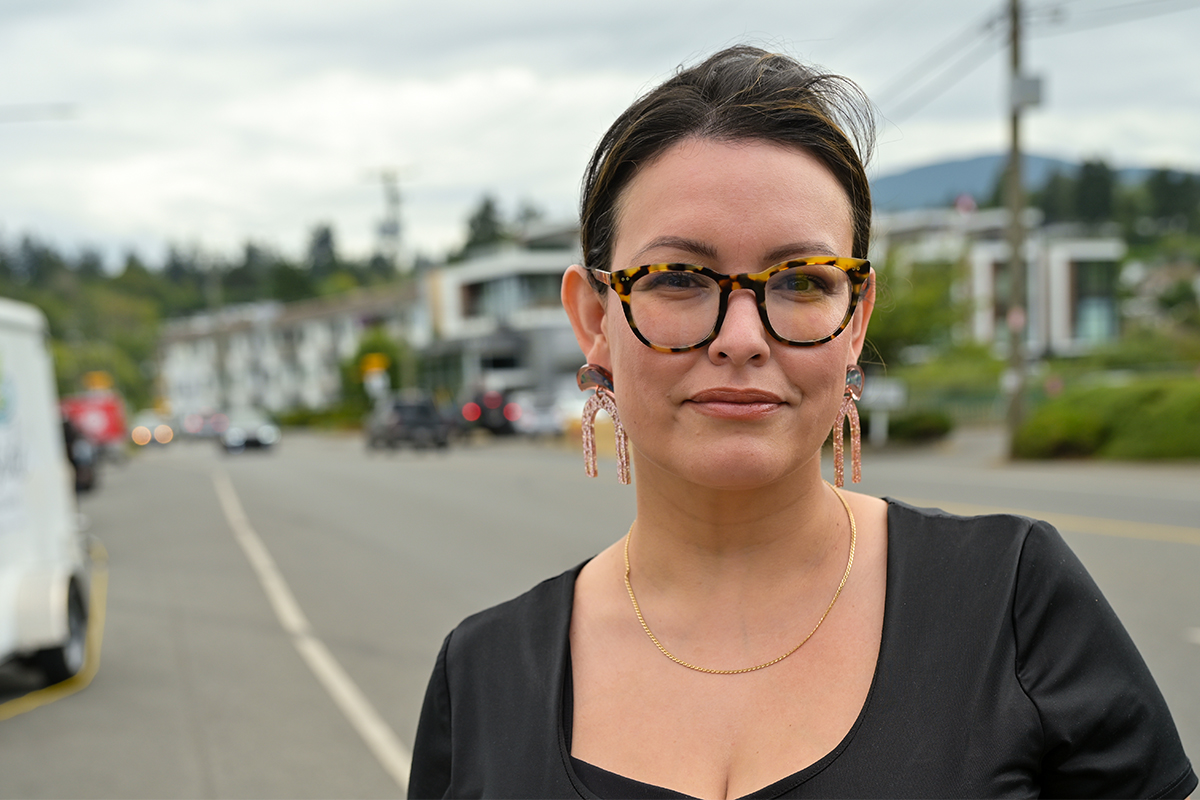
At some point every day, including sometimes on her lunch break, Cedar resident Jackie Wasyluk walks the popular Cable Bay Trail armed with a stack of postcards she hands out to everyone she encounters. One side of the card alerts people about an industrial development proposed for the west side of the trail, while the other side calls attention to a proposed subdivision for the east side of the trail.
Wasyluk and other members of Save Cable Bay, an unincorporated group that started as a Facebook page in December 2020, view these proposed developments as twin threats to the area’s biological diversity and to their peace of mind.
“It’s been my daily walk pretty much since I moved here 13 years ago and I just can’t imagine it being destroyed,” Wasyluk says. “It’s a stress reliever for me. It’s where I come after work to just let everything go and enjoy nature. There’s not a lot of places around where you can walk through the forest and see whales.”
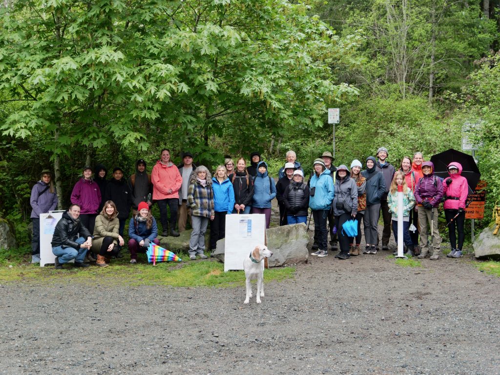
For the past three-and-a-half years, this group of volunteers has been learning on the fly how to be citizen activists. They have submitted Freedom of Information requests to get details of development proposals, filed complaints about aspects of the proposals, and organized a blockade in 2021 that they say stopped an area along the beginning of the trail from being logged.
The Cable Bay Trail is currently just a right-of-way, surrounded by private property, but the group hopes to ameliorate the impact of the proposed industrial development on the west side and stop the proposed subdivision from happening, while convincing the City of Nanaimo to turn the trail’s east side into a park.
Why is the Cable Bay Trail so beloved?
Located on Snuneymuxw First Nation territory in the southeasternmost corner of Nanaimo, bordering the small community of Cedar, the Cable Bay Trail is featured in many guidebooks and lists of recommended Vancouver Island hikes.
“It’s not just a regional trail, it’s a tourist destination,” Wasyluk says, adding that she regularly meets people on the trail who are visiting from many different countries.
Although it’s not a long trail, about 1.9 kilometres one-way, the Cable Bay Trail mostly lies within the City of Nanaimo but begins in Cedar, which is in the Regional District of Nanaimo (RDN). The trail terminates at Cable Bay, where people can explore a beautiful sandstone shoreline.
Though the Cable Bay Trail ends at a small bridge, many hikers continue on the path through a small patch of land owned by Mosaic Forest Management that leads to Joan Point Park, a 23-acre waterfront park overlooking Dodd Narrows. The narrows, which runs between Joan Point and Mudge Island, is renowned for its dangerous currents and frequent sightings of sea lions, sea otters and killer whales.

The Cable Bay Trail itself goes through Douglas fir forests and past several Garry oak meadows. The area is part of a thin band of coastal Douglas fir ecosystem which is one of the most imperilled ecosystems in Canada.
It also supports the highest number of endangered and at-risk species in B.C., according to Paul Chapman, executive director of Nanaimo and Area Land Trust (NALT). The highest number of those species are in the Garry oak sub ecosystem, he adds. For example, Cable Bay is one of only three places in Canada where Muehlenberg’s centaury, a small red-listed flower, has been found to grow, according to environmental assessments.
In 2021, NALT assessed different places in Nanaimo to identify gaps in the protection of older forests and Garry oak ecosystems where there are trees taller than 30 metres in areas more than 30 metres wide. Chapman says one of the areas that “lit up the map” was Cable Bay.
“We have an opportunity here to protect the [Garry oak ecosystems] … We’re down to the last remnant bits,” he says.
What are the developments being proposed for the Cable Bay area?
In 2005, Wilf Richard of Calgary bought 517 acres of the land encompassing both sides of the Cable Bay Trail. For several years, he tried to develop the roughly 400 acres that are in the City of Nanaimo into the Oceanview Golf & Resort Spa featuring an 18-hole golf course and about 3,000 residential units but ultimately couldn’t get the financing for it.
The other 97 acres are in the RDN, and he was able to log a sizable portion of that in March 2021.
In 2022, Richard sold the city land on the west side of the trail to Nanaimo Forest Products, the parent company of Harmac Pacific, which hopes to create an industrial development for forest-related uses there.
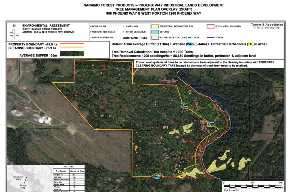
In December 2023, Nanaimo Forest Products submitted an application to the city that includes a request to have the land rezoned from AR1 (rural resource) to industrial.
Also in December 2023, Richard submitted an application to the city to create a subdivision on the east side of the trail called Cable Bay Estates with 34 lots, all at least two hectares in size. The land there is AR1 and doesn’t require rezoning for a subdivision with lots of that size.
The City of Nanaimo’s approving officers are reviewing the two development proposals, and there is currently no timetable for a public hearing about the rezoning of the industrial development proposed for the west side of the trail.
Who is behind the movement to Save Cable Bay?
Jain Alcock-White has lived in the Cedar area since 1980 and remembers hiking the Cable Bay Trail when she was in Brownies. She had gotten to know Wasyluk through their children’s activities and they often ran into each other on the trail.
So in December 2020 when they heard about proposed logging of the 97 acres along the RDN portion of the trail, they and a few other local residents decided to band together and create a Save Cable Bay Trail Area Facebook page (subsequently shortened to Save Cable Bay). Within a month, the Facebook group had more than 1,000 members.
“It’s up to people like us to stay on top of things,” Alcock-White says. “It’s an ultra-popular trail that so far it seems like the city doesn’t really think much of.”
In March 2021, some area residents received notice a couple days after the logging started that Oceanview Golf Resort & Spa would be doing timber harvesting on the 97 acres. Wasyluk and Alcock-White recall that it was difficult to get details about the logging plans, but eventually learned that while the RDN granted permission for the company to log the area, the company didn’t have a permit to cross the Cable Bay Trail with their equipment to a reach the smaller portion of the 97 acres that are on the east side of the trail.
Wasyluk and Alcock-White saw this as an opportunity for action. From Friday evening March 12 through Sunday evening March 14, Save Cable Bay members set up a blockade at each of the trail’s three access points to the east side to make sure the logging trucks didn’t cross over. The logging permit was only valid through that weekend because the following Monday was the beginning of nesting season, but logging continued that Monday on the west side of the trail. Members of Save Cable Bay sent frantic messages to RDN officials who eventually came out to the trail late that afternoon and issued a stop work order.
Wasyluk says the group’s actions prevented that portion of the east side of the trail from being logged. “I had never done anything like that before. It was a bit stressful,” she recalls.

Battle over the buffer size for the the west side of the Cable Bay Trail
The Save Cable Bay group has branched out from Facebook and created a basic website and recently an Instagram page. The group has focused its attention on the areas around the Cable Bay Trail that are in the City of Nanaimo. Waslyuk says that all along she has been keeping the Snuneymuxw First Nation in the loop about the proposed developments.
Their goal for the west side of the trail is to minimize the impacts of having an industrial operation so close to it. A big part of that is the size of the buffer between the trail and the development.
In 2022, Harmac Pacific’s initial plans included the creation of a 50-metre buffer between the Cable Bay Trail and their proposed industrial development on the trail’s west side. But NALT, Save Cable Bay and others criticized the buffer size as insufficient protection against edge effects — where logging on one side of a trail creates more sunlight and wind throw that impacts standing trees and the understory of those trees on the trail’s other side.
At a May 2022 Nanaimo City Council meeting, Chapman and Alcock-White were among those who shared their concerns and advocated for a 100-metre buffer instead. The 100-metre buffer size is based on a rule of thumb that a buffer should be three times the size of the tallest trees, and there are many trees about 30 metres high along the trail, Chapman explains.
“Wherever it’s less than 100 meters, then those edge effects will be experienced across the trail to the other side and that really will diminish the natural values of that older forest,” he says.
In what was considered a win-win at the time, Harmac agreed to expand the buffer to an average of 100 metres along the trail. But when Save Cable Bay members sent a FOI request to receive documents related to the Cable Bay developments, they were aghast to see that the plans for the industrial development submitted to the City of Nanaimo in December 2023 included a 50-metre buffer along a large portion of the trail with a 150-metre buffer in other spots.
“We were honestly shocked when we saw their application submitted to the city and it was 50 metres pretty much all the way down the trail until it became a cliff,” Wasyluk says. She is looking forward to an opportunity to share the group’s concerns about the buffer distance when there is a public hearing for the rezoning.
Harmac agreed to the 100-metre buffer proposed during the May 2022 council meeting because that was what was asked for by NALT and other groups, Harmac CEO Paul Sadler told The Discourse, adding that he understood it was based on an estimate that buffers require a necessary distance of triple the height of the 30-metre trees.
“They said it’s got to be 100 meters. So we looked at the layout of the land. And in fact, 100 meters is probably too little, especially as you work your way down towards the water. So after examining the lay of the land and the topography and what would work best for the trail, a 100-meter average is much more sensible. So it’s actually an improvement on what was originally proposed by NALT,” he says.
Sadler acknowledges that the buffer is narrower at the top of the trail, but that is by design, and says his interest is to protect the entire gully as the trail nears the water.
“That’s the purpose of the 100-meter average, is it can be a little bit narrower at the top end of the trail, where it’s not unique, it’s wide open anyway. And then the buffer will widen as the trail goes down into the gully towards the ocean, which is where you really want to protect the environment of the trail. The characteristics of the trail really all relate to the bottom portion of the trail. We don’t even own the trail all the way to the ocean,” he says.
The total amount of land that the buffer encompasses is approximately 27 acres out of a 211-acre parcel, says Sadler, and the creation of this protected property is part of an ongoing legacy project that started when the company first partnered with the city to build the Cable Bay Trail, which first opened in the summer of 1996.
Harmac’s intention to create an industrial park is based on the location of the property and is a response to the city’s severe shortage of industrial properties, says Sadler. A 2023 report from Colliers International stated that a lack of supply of industrial land has caused an estimated 0.71 per cent vacancy rate and significantly driven up rents.
As the land west of the Cable Bay Trail abuts the Harmac pulp mill and an industrial landfill, it made sense to put the new industrial property there, says Sadler, and that was partly why they purchased it.
“Of course we’re interested in sustainability, our business depends on sustainability,” he says. “But the objective here is to provide land for industries that can provide high paying jobs … There’s two ways around affordability, living in society today, and one of them is to make sure you’ve got high paying jobs for people.”
In the meantime, the Save Cable Bay group is ramping up its opposition to the development proposals.
Members weren’t able to find environmental assessments for the developments on both sides of the trail, so they filed freedom of information requests to see them. Wasyluk says she was told by a Harmac representative that it is not company policy to share internal documents, though some of these are now available online.
Alcock-White, who has a background in environmental management and is on the board of Yellow Point Ecological Society, sent a series of letters to the City of Nanaimo pointing out perceived issues with both assessments and calling for additional assessments. NALT sent similar letters to the city, Chapman says.
On May 2, Alcock-White took it a step further by sending letters of complaint to the College of Applied Biology about the ecological assessments done for the proposed developments on each side of the trail. She has also recently contacted the Programme for the Endorsement of Forest Certification and Forest Stewardship Council with concerns that Harmac’s development plan on the west side does not adhere to the company’s stewardship policies.
Related story: Saving the Red Gate forest
Could the east side of the Cable Bay Trail become parkland instead of a subdivision?
In January 2021, not long after its inception, the Save Cable Bay group started a petition asking the City of Nanaimo to make the Cable Bay area into a park. The original petition called on the RDN to make the 97 acres around the beginning of the trail into a park, but since some of these lands were logged, they have updated the petition to focus on the City of Nanaimo portion. The petition now has more than 22,000 online signatures and includes information about the proposal developments on each side of the trail.
Alcock-White says she considers the east side of the Cable Bay Trail the most important in part because it is the primary land route to reach Joan Point Park and Dodd Narrows.
It’s why Save Cable Bay and others engaged in Nanaimo’s Official Community Plan that was updated in 2022, and succeeded in getting the land where the 34-lot subdivision is proposed placed outside of the city’s urban containment boundary. This means that the city will not supply water or sewer to the property, something that Save Cable Bay members hope will deter buyers.
The updated OCP also has a section on waterfront that now includes a recommendation to “prioritize securing an upland public trail between Cable Bay Trail, Joan Point Park, and the city boundary to the south.”

Ben Geselbracht is a Nanaimo city councillor and is on the RDN board of directors. He explains that the rationale behind urban containment boundaries is that “it’s way more environmentally sound to build up as opposed to build out.”
Along with that density, he says it’s important for there to be nearby green spaces for people to enjoy nature. He notes that with a growing population, including the large Sandstone development in South Nanaimo with plans for 2,200 residential units, the need for green spaces will be greater than ever.
According to Geselbracht, the RDN maintains a parkland priority list that is not publicly available and as a result he can’t say whether the area east of the Cable Bay Trail is on the list. It is important, he adds, for people who want the Cable Bay area to become parkland to voice those desires to the city and RDN.
On May 7, Chapman gave a presentation to the RDN parks and trails committee about the ecological value of protecting the Cable Bay area. He told the committee that while protecting Harewood Plains should be the top priority for the conservation of Garry oak ecosystems, Cable Bay is in the top 10 of such areas in the province to protect.
If Cable Bay is a place that the city decides to conserve, Geselbracht says buying it from the developer would likely involve a partnership between the city, the RDN, ideally the province as well as individual donors.
The Discourse reached out to Richard of Cable Bay Estates Ltd. and his project manager Glenn Brower, but neither party were able to comment on the status of the subdivision or community proposals to convert some of this property to a park.
Alcock-White and Wasyluk continue to encourage the 2,900 members of the Save Cable Bay Facebook group to send emails to local elected officials urging them to contact provincial and federal leaders about protecting the east side of Cable Bay Trail and making it a park.
In a May 10 post, Wasyluk referred to the trail as “the jewel of Nanaimo,” and said she will be posting a call to action every day until it is confirmed that the city is going to take action toward creating a Cable Bay Park.
Alcock-White continues to lead trail walks so residents can learn about the medicinal uses of plants and the ecology of native forest and meadow species.
Editor’s note, June 7, 2024: a sentence about Harewood Plains that was unclear regarding its current status has been removed.
What did you think of this story?
Your feedback after we publish a story helps ensure we're always improving our reporting to better serve you
Author

Related Articles
Snuneymuxw Days shares culture with Nanaimo community
Health and wellness event features sport, traditional games and a feast.
Why are nurses in Nanaimo on strike?
Hundreds of nurses and healthcare workers picket Nanaimo Regional General Hospital.
‘Drag racing’ disrupting Departure Bay residents
Residents ask city council to do something about loud cars and motorcycles late at night.